Bruce Jones’ new book “To Rule the Waves: How Control of the World’s Oceans Shapes the Fate of the Superpowers” (Scribner) — praised by Nature magazine as one of its top five science books on the week of its publication — charts the myriad ways in which competition on and below the oceans is reshaping the dynamics of globalization, geopolitics, and global energy flows. Jones also highlights the essential role that the oceans play in climate change, and the manner in which those changes are already playing out in real time. He highlights the varying impacts of a changing climate in different geographies, and challenges the conventional wisdom that climate change will necessarily drive cooperation — rather, near-term adaption is already fueling additional competition between the world’s major powers. The following is a modified excerpt from the section of the book entitled “The Power of the Seas.”
Thant Myint-U, the noted historian of modern Burma and grandson of former United Nations Secretary General U Thant, has documented the myriad ways in which China and India compete for resources and influence in what he’s termed “the new crossroads of Asia.” The features that make Myanmar attractive to both these two Asian giants are two: large estimated reserves of energy, both onshore and off; and the country’s long Andaman Sea peninsula. From China’s position, access overland to Myanmar’s coast would give them a new opening to the Indian Ocean, one that bypasses the Near Seas and the Malacca Strait — and the U.S. fleet. But should China secure such a route, it would put India’s navy on the front line of dealing with the People’s Liberation Army Navy. The Nicobar Islands are India’s farthest outpost and the place that the Indian navy first encounters their Chinese counterparts as they sail out through the Malacca Straits. But both nations face a challenge in developing Myanmar’s geography for strategic purposes — because both Myanmar and the Nicobar Islands face potential devastation from the changing climate. Of all the places in the world most likely to be profoundly harmed from rising sea levels and increased frequency of storms, the Bay of Bengal and the Nicobar Islands are the most likely to face sustained, wrenching change.
One such storm struck on May 1, 2008, when what was officially known as an “Extremely Severe Cyclonic Storm Nargis” blew across the Bay of Bengal, swamping several of the Nicobar Islands, and gathering speed. It hit the western shore of Myanmar on May 2. The U.S. Navy/Air Force Joint Typhoon Warning Center estimated its maximum wind speeds at 130 miles per hour. Hitting the low-lying delta of the Irrawaddy River, it pushed a storm surge an unimaginable 25 miles inland. By morning, 138,000 people had been killed.
It was not the first time the Bay of Bengal had been wrecked by a cyclone. Nargis was not even the deadliest cyclone to visit the bay in recent times; in 1970, the Bhola cyclone swept through the Bay of Bengal, made landfall in eastern Bangladesh, and killed an estimated five hundred thousand souls. Still, the scale of devastation caused by Nargis was immense, and changed the course of Burma’s history. In the wake of the devastation, the regime had no choice but to open the country to the hundreds of NGOs and dozens of U.N. agencies clamoring to help. It opened the floodgates of Western money and influence. Among other effects, it caused Thant to focus his attention, and that of his NGO, on a different kind of vulnerability that Myanmar faced; not just the new “imperial” competition from its giant neighbors, but from climate change.
Sea-level rise and storm surges are bad enough; but with advanced warnings, planning, and adaptive measures, the effects on human life and economic infrastructure can be mitigated. But Thant saw Myanmar experiencing a different phenomenon as well, a change in the patterns of the monsoon rains and alluvial flooding, one of the effects that arises from a complex, but by now well-mapped, interplay between melting sea ice in the world’s poles and changing temperatures and salinity of waters worldwide.
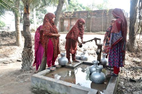
Throughout Myanmar’s recorded history, monsoon flooding predictably hits what’s known as the “dry zone” during the months of June through September. Moisture blown in from the Andaman Sea and the adjacent Arabian Sea accumulates in the highlands of the Himalayas and Myanmar’s northern mountain ranges. Then the winds change course and pull that moisture down through Southeast Asia’s great floodplains, the Ganges and the Irrawaddy, in normal years flooding as much as 40% of Myanmar’s landmass. This creates the necessary conditions for growing rice — the primary source of caloric intake for 2.7 billion people in Asia, supplying as much as 58% of the energy intake of several of the region’s populations. But the patterns of rain appeared to be shifting.
Myanmar was feeling the effects of a series of interlocking oceanic phenomena unraveled by a remarkable piece of oceanographic detective work undertaken by researchers at the Bigelow Laboratory for Ocean Sciences in East Boothbay Harbor, Maine, and at the Naval Postgraduate School, in Monterey, California. At the Bigelow lab, a scholar named Joaquim Gos had funding from NASA to use satellite observations of chlorophyll and sea-surface temperature readings to develop a map of nitrate concentrations in the oceans — part of NASA’s contribution to global circulation modeling. His mapping found unusually large blooms of phytoplankton in the Arabian Sea (on the other side of the Indian subcontinent from the Bay of Bengal and the Andaman Sea). That led to the discovery that the Arabian Sea had been cooling, affected by changes in the upwelling of cold bottom waters. Careful forensics showed that increased upwelling was related to wind patterns over the ocean, themselves a function of changing patterns of the Asian summer monsoon. Further research showed a strong link between snow patterns in the highlands of Europe and Asia and monsoon patterns—a link that had been theorized as early as the late 1880s, but never demonstrated.
Using advanced climate modeling, the team found a clear set of patterns: a decline in snow coverage in Europe and Asia from the early 1990s onward meant warmer air over these continents, which was affecting glacier formation in the Himalayas, which was affecting rain concentration in the Asian highlands, which was affecting the timing and strength of the monsoon rains. And leading to increased flooding.
In a normal year, up to 40% of the Ganges and Irrawaddy river deltas flood from the monsoon rains, and over centuries, the local populations have built up their farming and infrastructure around that predictable floodplain. But in flood years, up to 70% of the deltas can flood, with devastating effects. And in the last decade, the timing of the monsoons has been increasingly unpredictable, and floods increasingly common.
For the rice farmers who depend on the predictability of the monsoons to prepare their rice fields, these fluctuations were debilitating. And so many of them left the dry zones and decamped to other parts of Myanmar — becoming, in effect, internal climate refugees. They ended up at the edges of parts of Myanmar historically dominated by different ethnicities, and recently torn by more than 50 years of civil war. Myanmar’s fragile young democracy was already coping with increased frequency of cyclone and storm-surge damage, dramatic global fluctuations in energy prices, and intensifying competition between China, India, and the West. Adding in a loss of productivity in the rice crop — the production and trade of which accounts for nearly half of Myanmar’s GDP — as well as large numbers of internal climate refugees, and Thant was becoming worried that Myanmar’s political system might not be able to cope. “I’m worried that Burma could become the world’s first climate-induced failed state.”
The effects would not be limited to Myanmar’s population of 56 million. On the western side of Myanmar, China has begun to invest billions of dollars in Rakhine State, to build both an oil pipeline and a deepwater port at Kyaukphyu, at the northern tip of Ramree Island. Kyaukphyu has a natural harbor and has long been an important outpost for the trade in rice between Myanmar and India. If fully operationalized, the port would realize China’s bid for an equivalent to the Suez Canal — a passageway that would connect Chinese rail and trade directly to the Indian Ocean, bypassing the Malacca Straits. But instability on land and rising sea levels threaten the viability of the project.
All of this is impacted by oceanic dynamics playing out as far away as the North Atlantic and the Antarctic. In the largest sense, the oceans are one, as the Royal Navy used to say, and so is climate change. It’s for this reason that climate change is usually viewed as a “we’re all in one boat” problem that will logically drive cooperation between governments around the world. But what’s equally true is that every sea, and every shore, is distinct; and climate change is playing out very differently in different waters of the world. That reality of variation is not driving cooperation, but rather adding to the competition over command of the seas.
Related Books


Commentary
Competing over climate: Myanmar’s valuable and climate-vulnerable geography
October 18, 2021